The OTP CTA project is a version of the OpenTripPlanner (OTP) software tailored for use in the city of Chicago by the Chicago Transit Authority (CTA). It also adds features to the core OTP software.

This project is part of the 2013 Data Science for Social Good fellowship, in partnership with the CTA. We implemented OTP for Chicago because the CTA wanted to use OTP Analyst to visualize how public transit affects residents' mobility.
OTP is an open source trip planning software package, originally developed by OpenPlans.
The core of OTP is a transportation routing engine - graph algorithms that find the shortest/fastest path between location a and b through transit, biking, and other transportation modes. This routing engine powers several user-facing apps, some for transit riders and others for planners:
- OpenTripPlanner app (
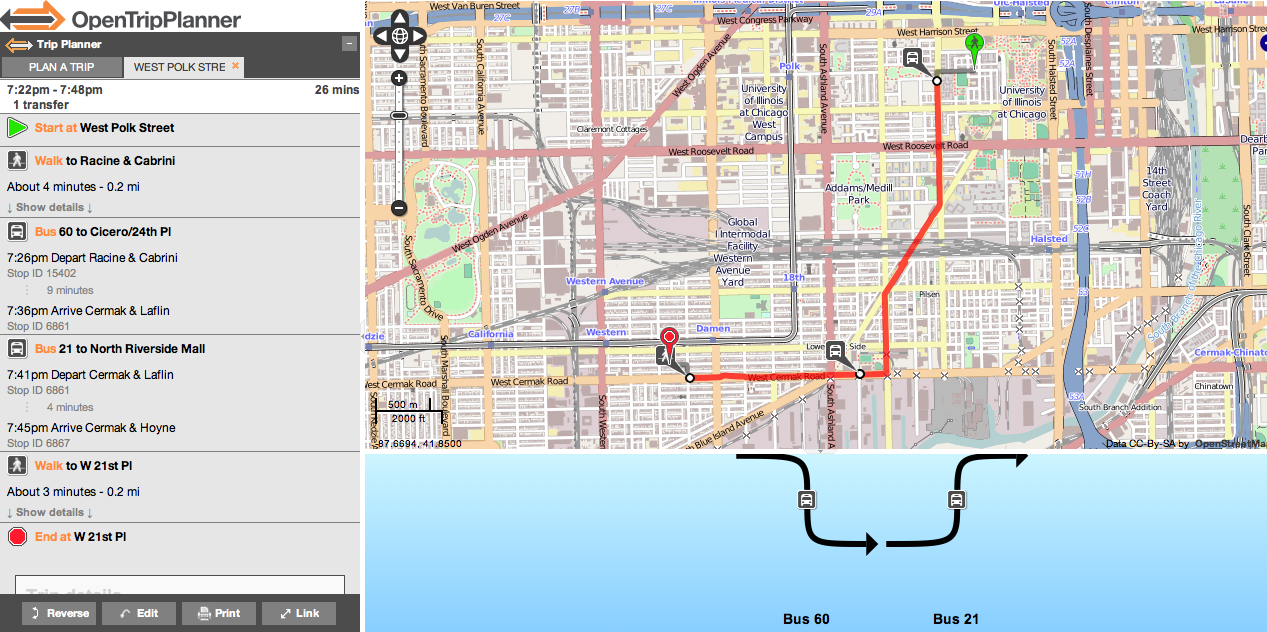
opentripplanner-webapp): Basic trip planning tool, similar to getting trip directions through Google Maps. The intended user is anyone figuring out how to get from here to there. The app finds a route from a single origin to a single destination at a time, and display the route to the user.
- OTP Analyst app (
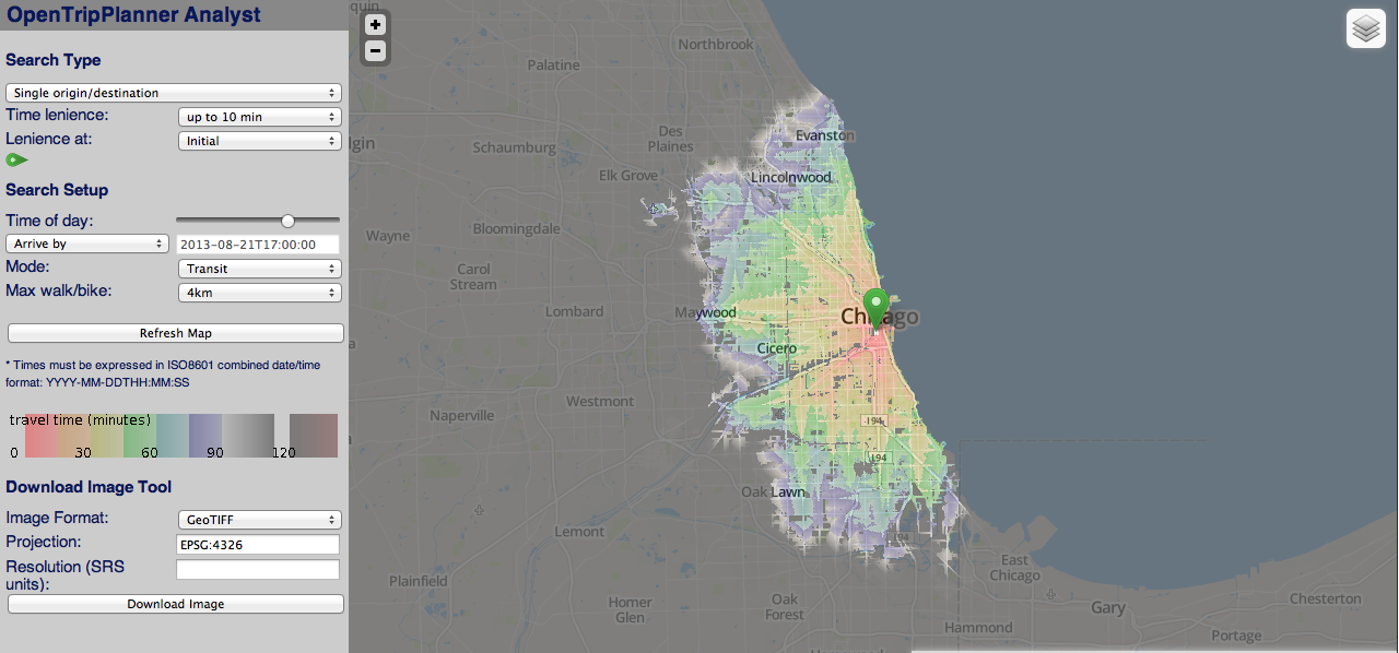
opentripplanner-analyst-client): travel-time maps for transportation planners. From a single origin point, this app calculates routes to a grid of destination points, then generates a map overlay color-coded by travel time. There are several modes which allow for addition of a second set of routing parameters for comparison. The intended users are transportation planners trying to visualize and understand mobility in a given city. For an introduction to OTP Analyst, click here.
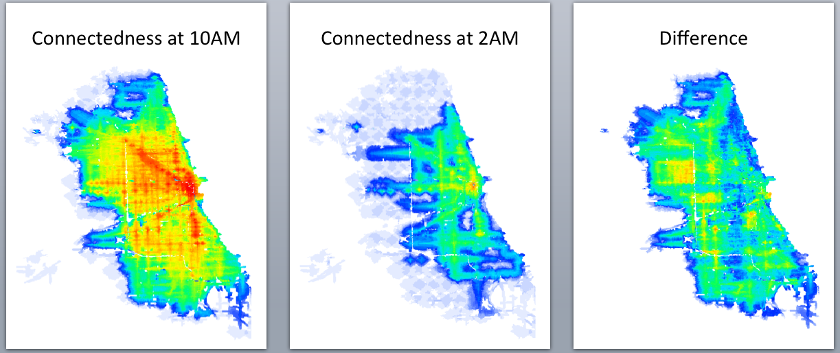
- Batch analyst app: there's also an offline "batch analyst" application, which allows for a wider range of routing use cases. You can route from a set of origin points to a set of destination points, outputting travel times (and possibly other information), either in CSV form or as a TIFF raster that other applications can use (i.e. desktop GIS software such as QGIS, which was used to generate the sample images below).
This project assumes you're already familiar with OTP. To get started, check out the project's very informative wiki and the main OTP repo.
The core OpenTripPlanner package is now being developed by Conveyal.
This is a version of OpenTripPlanner customized for use by the CTA. This repository was cloned from the OTP repository, then four changes were made:
-
OTP and OTP Analyst for Chicago: optimized the JavaScript in the trip planner and analyst client webapps for use in the city of Chicago - auto-centered camera on Chicago, removed references to the D.C. Purple Line.
-
Aesthetic changes to OTP Analyst: made minor fixes and aesthetic changes to the webapps (fixed broken map options, added new options, changed color legend for trip times)
-
New OTP app for general accessibility: created a new webapp
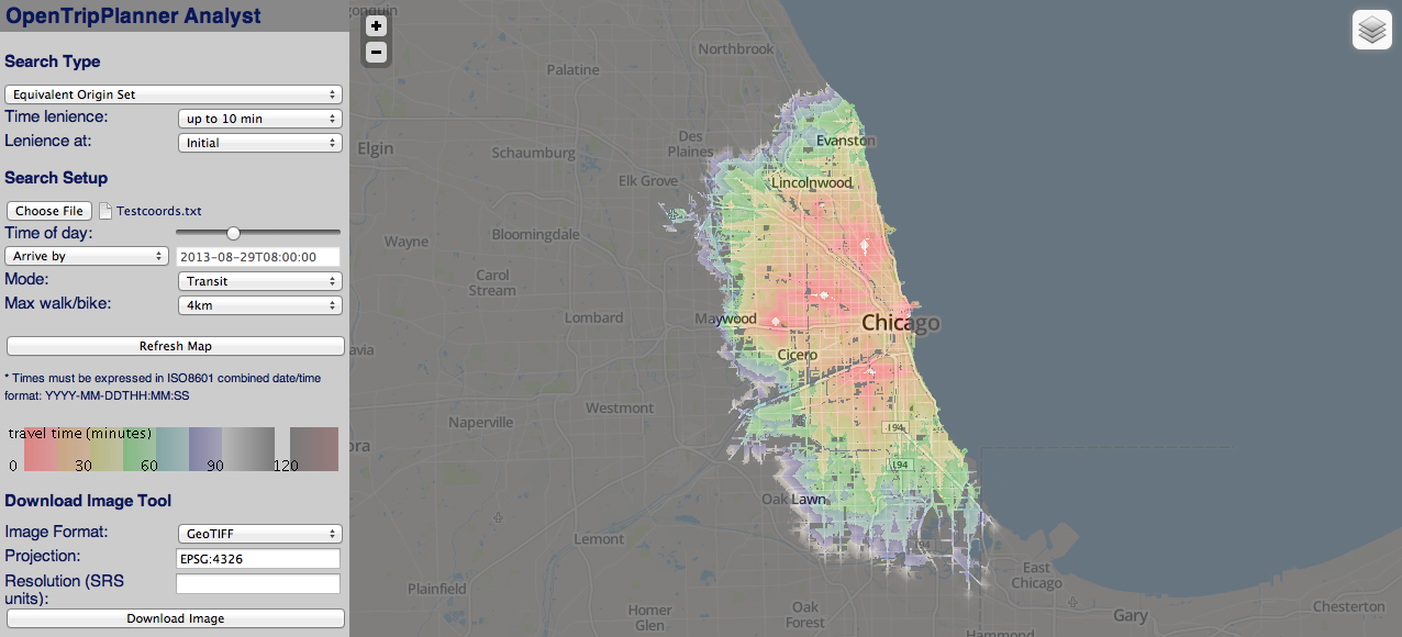
opentripplanner-ga-client. Instead of visualizing trip times from one point on the map to every other point, this tool visualizes how "accessible" or "connected" each point on the map is to every other. The app works by calclating routes from a specified set of points (the user can upload a file of lat-long coordinates) to a grid of points. The map colors change based on the mode selected - currently, it can be colored by the average travel time to the origin points, or by the travel time to the closest origin point. In addition to the webapp, this required modifying several java files to allow for the extension of analyst features required for the opentripplanner-ga-client and related future functionality. NOTE: The GA client does NOT use Batch Analyst. It merely expands upon the Analyst Client.
For a more thorough list of changes, click here.
We've deployed the OTP trip planning, analyst, and general accessbility apps for the Chicago Transit Athority to use.
-
Trip planning demo: http://ec2-50-112-86-42.us-west-2.compute.amazonaws.com:8080/opentripplanner-webapp/
-
Analyst demo: http://ec2-50-112-86-42.us-west-2.compute.amazonaws.com:8080/opentripplanner-analyst-client/
-
General accessibility demo (potentially unstable): http://ec2-50-112-86-42.us-west-2.compute.amazonaws.com:8080/opentripplanner-ga-client/
NOTE: These demos are hosted on the CTA development EC2 instance, and as such may be taken down from time to time.
Well, that depends on what exactly you want to do with the software.
-
https://github.com/openplans/OpenTripPlanner/wiki/Install will get you started with OpenTripPlanner in general.
-
https://github.com/dssg/cta-otp/wiki/Using-Eclipse contains brief instructions about how to set up a development environment in Eclipse. At the bottom is a link to a guide to set up a local test server using Tomcat.
-
https://github.com/dssg/cta-otp/wiki/AWS-EC2-Setup contains information on how to get this build of OpenTripPlanner up and running on an Amazon EC2 instance.
- Please check our to-do list to see what's on our roadmap. Pull requests welcome!
-
All of the work in this repository that differs from the main OTP build has been carried out by David Sekora. He can be reached at DJSekora@gmail.com
-
OTP itself has an active mailing list: https://groups.google.com/forum/#!forum/opentripplanner-users
-
For more technical OTP development questions: https://groups.google.com/forum/#!forum/opentripplanner-developers
As found at the beginning of every source file:
This program is free software: you can redistribute it and/or modify it under the terms of the GNU Lesser General Public License as published by the Free Software Foundation, either version 3 of the License, or (at your option) any later version.
This program is distributed in the hope that it will be useful, but WITHOUT ANY WARRANTY; without even the implied warranty of MERCHANTABILITY or FITNESS FOR A PARTICULAR PURPOSE. See the GNU General Public License for more details.
You should have received a copy of the GNU General Public License along with this program. If not, see http://www.gnu.org/licenses/.